TerraStation Modules
TS Base System
Comprehensive borehole data analysis and project management tools for well evaluations.
Key features of TerraStation Base System:
• Supports up to 10,000 wells per project
• Data loading from LIS, DLIS, LAS, and ASCII files
• QC tools for curve splicing, editing, baseline shifting
• Directional surveys with TVD, TST, TVT computation
• Project management tools for bulk data import
• Base mapping with bubble maps and curve profiles
• Crossplots, histograms, bar graphs, ternary diagrams
• Dipmeter analysis with stereonet capabilities
• Pressure modeling and stress analysis functions
• Multi-well, multi-zone processing capabilities
• Export to multiple formats (LAS, DLIS, LIS, ASCII)
• Over thirty types of composite log display tracks
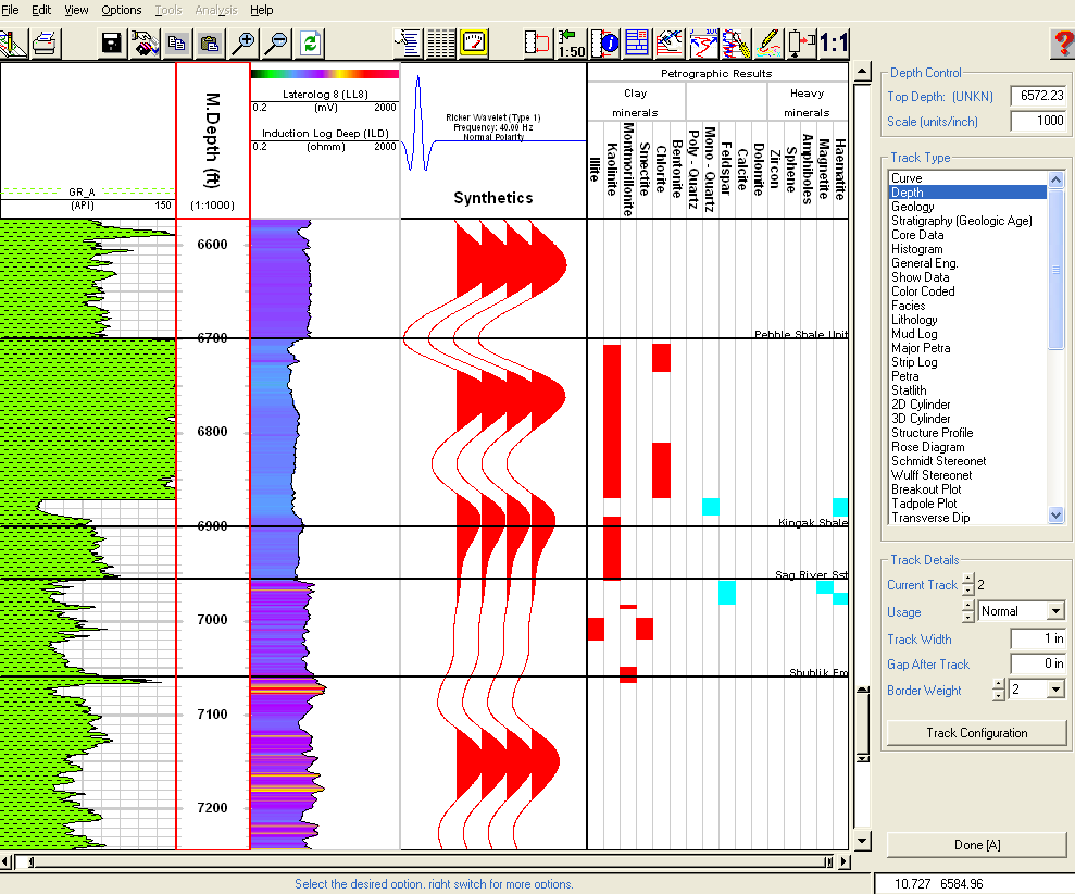
Petrophysical Analysis
Advanced well evaluation tools for deterministic and probabilistic models.
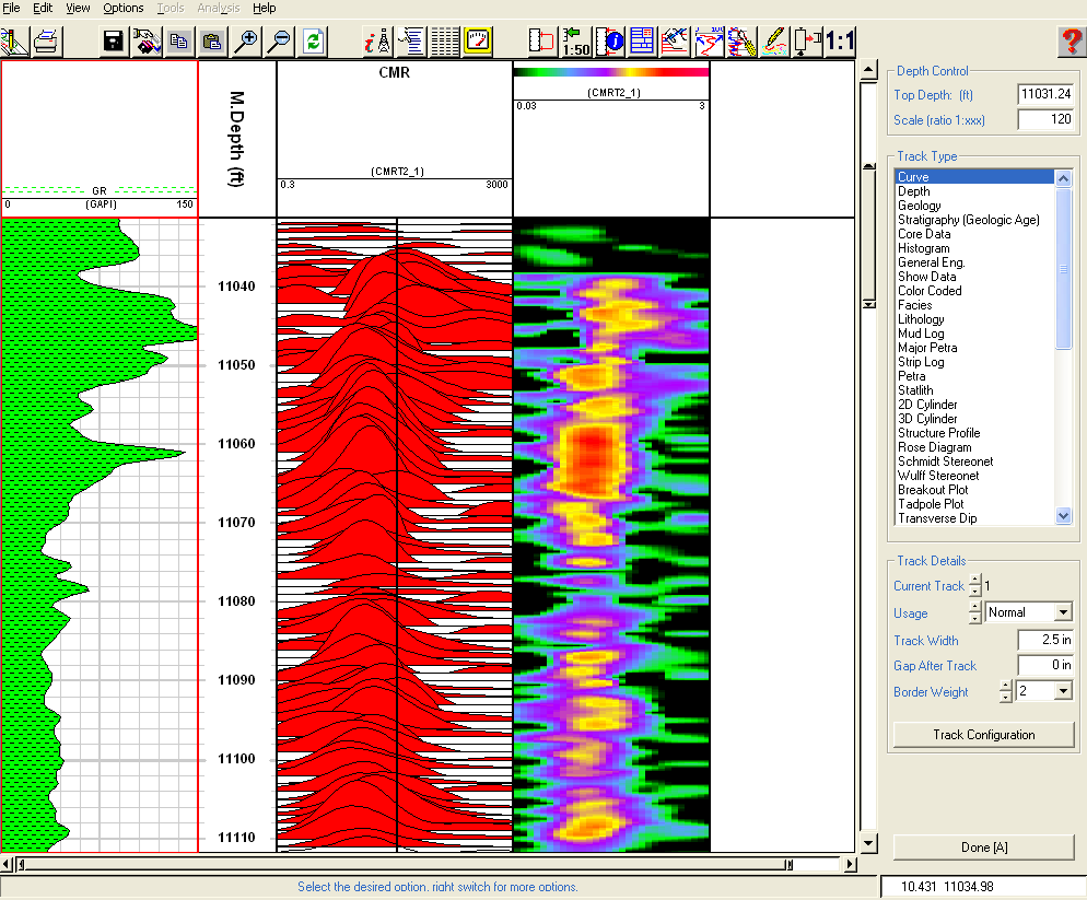
Key features of Petrophysical Analysis:
• Supports all major logging company formats
• Comprehensive borehole and environmental corrections
• Flexible zonal analysis with depth-based parameters
• Multi-well processing with command language
• Full suite of deterministic analysis options
• Probabilistic modeling capabilities
• Statistical mineralogy modeling
• CMR and NMR processing capabilities
• Shaly sand and complex lithology analysis
• Extensive porosity computation methods
• Multiple water saturation computation models
• Extensive porosity and water saturation computation methods
Borehole Imaging
High-resolution borehole imaging for structural and sedimentological interpretations.
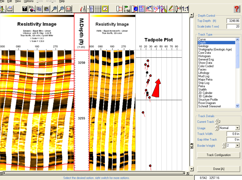
Key features of Borehole Imaging:
• Supports all major imaging tools (FMI, EMI, HMI, etc.)
• Multiple data format support (LAS, LIS, DLIS)
• Speed corrections, pad/flap correlations
• Gain correction and dead button removal
• Dynamic and static normalization options
• Interactive color mapping control
• User-definable pick categories
• Interactive "point & shoot" feature identification
• Full suite of dip analysis displays including stereonets
• 3D visualization capabilities
• Fracture aperture analysis
• Integration with cross-section displays
Sonic Waveform Processing
Computation of compressional, shear, and Stoneley travel times.
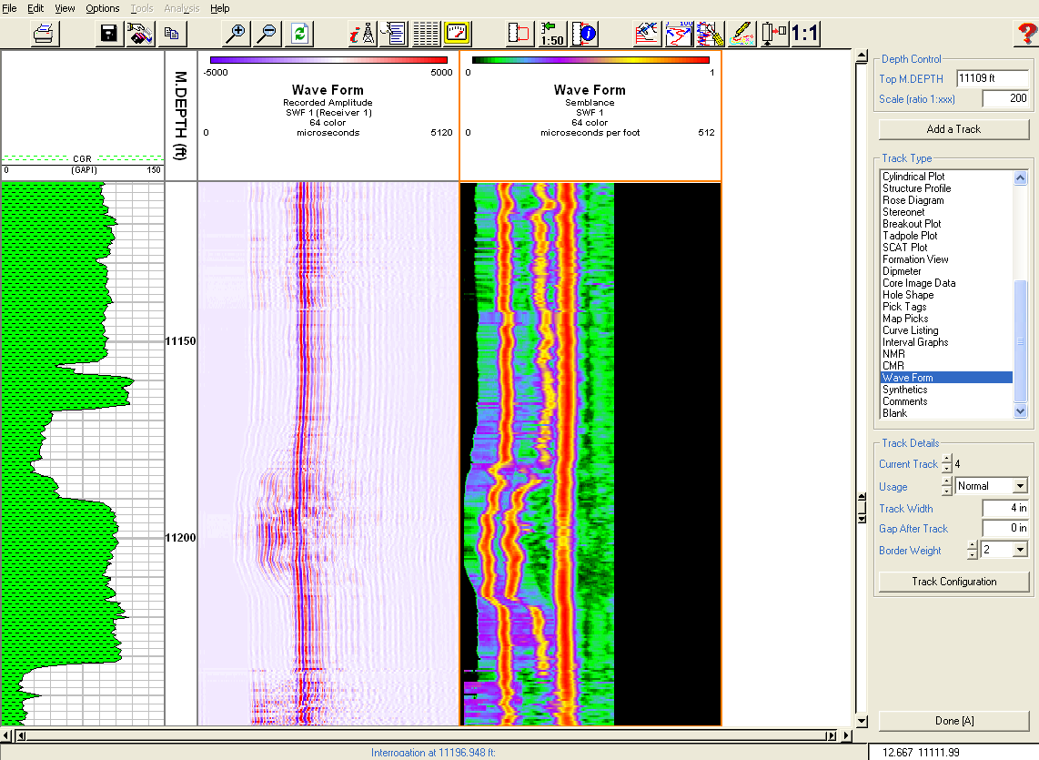
Key features of Sonic Waveform Processing:
• Loads data from LIS and DLIS formats
• Computes compressional, shear, and Stoneley travel times
• Both wiggle trace and VDL display options
• Semblance computation methods
• Dipole anisotropy analysis
• Frequency dispersion analysis
• Waveform muting capabilities
• Integration with synthetic seismogram generation
• Full or Fast Fourier transform options
• Instantaneous phase/frequency/amplitude computation
• User-controlled color maps
• Noise component filtering
Cross Section & Correlation
Multi-well visualization and correlation for detailed stratigraphic analysis.
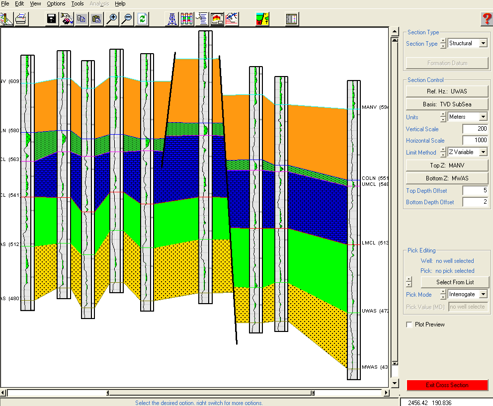
Key features of Cross Section & Correlation:
• Handles up to 300 wells per section
• Supports deviated and horizontal wells
• Interactive top picking
• Multiple log template support
• Integration with mapping module
• Three interpretative overlays per section
• Structural and stratigraphic display options
• Ability to incorporate raster images
• Interactive well gap feature
• Fault and pinch out addition capabilities
• 3D fence diagram creation
• User-definable cross-section title blocks
Mapping
Spatial data analysis for property distribution and grid operations.
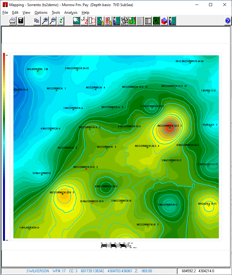
Key features of Mapping:
• Base maps and contour mapping
• 3D perspective views capability
• Bubble maps and curve profile maps
• Kriging and geostatistical analysis
• Handles deviated well data
• Grid-based and triangulation mapping
• Surface to surface calculations
• Integration with DEXTR module
• Volumetric calculations
• Rose diagram generation
• Trend surface analysis
• Export to Surfer™ and ZMAP™ formats
Geomechanics & Pressure Modeling
Evaluate stress distribution, pressure regimes, and well stability.
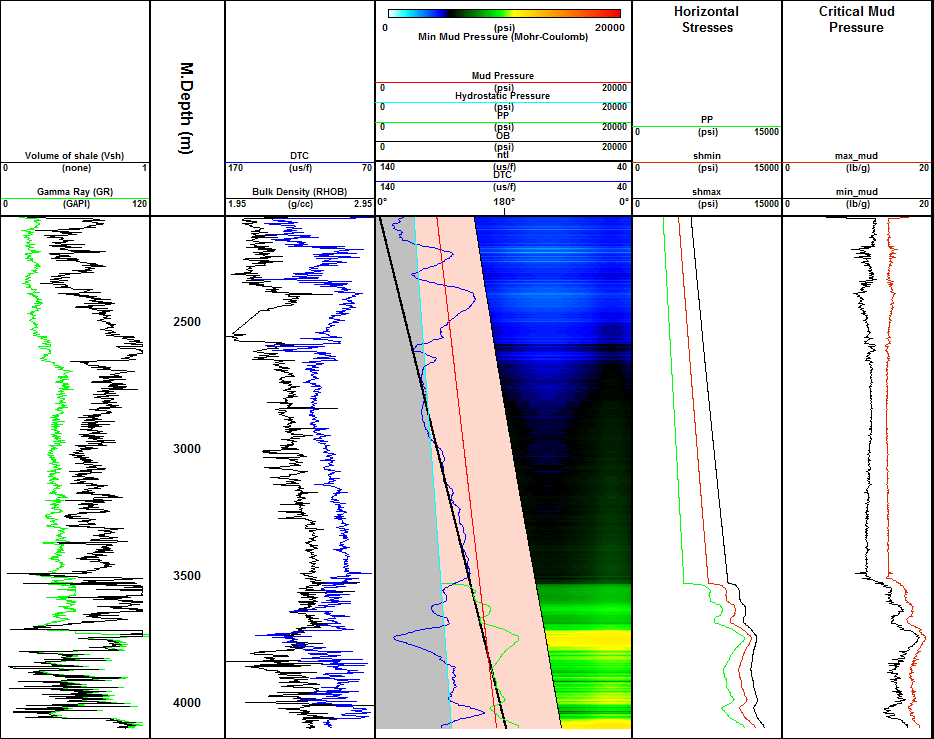
Key features of Geomechanics & Pressure Modeling:
• Pore pressure modeling (Eaton, Bowers methods)
• Fracture pressure modeling
• Maximum stress computation
• Critical mud pressure window modeling
• Multiple failure criteria support
• Borehole stress displays
• Integration with dip analysis
• Pressure modelling track in IMAGELog
• Rock properties computation
• Brittleness Index calculation
• Analysis of LOT/XLOT data
• Critically stressed fracture analysis
Dipmeter Processing & Analysis
Process and analyze dipmeter data for geoscience exploration and production.
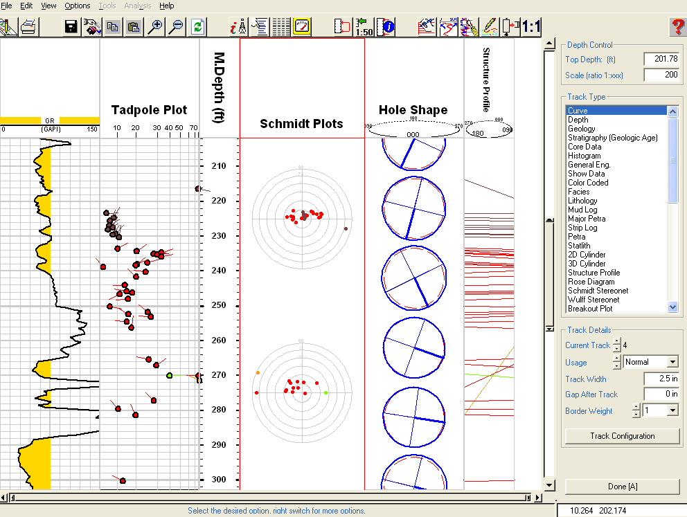
Key features of the Dipmeter Processing & Analysis:
• Supports 4, 6, and 8 arm tools
• Borehole geometry corrections
• Speed and swing-arm corrections
• SCAT plot capabilities
• Dip Walkaway analysis
• Structural dip removal options
• Interactive stereonet analysis
• Display as curves or pseudo-images
• Magnetic declination corrections
• Fisher statistics reporting
• User-definable dip classification scheme
• Integration with cross-section displays